Description
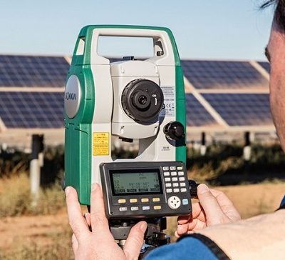
Leica FlexLine TS10 Total Station
Leica FlexLine TS10 is a high-end manual total station, enabling you to carry out high-demand survey tasks with Leica Captivate software. This way you can participate in the world of 3D by benefiting from 3D views of your measured data.
The TS10 solves daily professional challenges and tasks for growing demands within surveying and mapping, building construction and civil engineering:
- Managing directors of construction departments benefit from minimal downtime of your survey crews to deliver projects under budget and in time.
- Survey managers can rely on the highest product durability in the market, which increases your planning certainty.
- Surveyors work faster by measuring more points per day with less measurement errors and rework.
Leica FlexLine: The new generation of manual total stations
The new Leica FlexLine series is based on a proven product concept, revolutionising the world of measurement and survey for nearly 200 years. Unlike any other manual total stations in the market, Leica Geosystems manual total stations focus on providing the highest quality, the lowest total cost of ownership and the longest durability in the industry, enabling users to work with purpose-driven solutions for the best performance results.
AutoHeight: Revolutionising instrument height measurement
The TS10 offers the world’s first AutoHeight feature as an option. AutoHeight enables the instrument to automatically measure, read and set its instrument height. Prevent time-consuming manual effort and eliminate critical errors during the instrument setup when this revolutionary feature uses a laser from the instrument to measure to the ground and automatically passes the measurement to the software.
Leica Captivate software: Comprehensive, intuitive and easy to use
The TS10 is equipped with the Leica Captivate field software, a comprehensive application-based software package. This intuitive, familiar software helps you to capture even more points than before. You are also able to tie into the modern 3D dataflow and rigorous quality assurance and control routines.
Use it trouble-free
Increase productivity and minimise downtime by relying on instruments that simple work and come with a global service and support network.
Choose products that are built to last
Even after years of use under harsh conditions (like mud, dust, blowing rain, extreme heat and cold), FlexLine still operates with the same high level of accuracy and reliability.
Control your investment
Instrument quality has been our standard for almost 200 years, which is why you can count on a lower investment over the entire instrument lifetime and do not have to worry about unexpected costs.
Profit from mobile connectivity
With optional mobile internet access, you can share your data online much faster, receive design data from your designers and engineers onsite, and use Leica Geosystems Services such as Leica Exchange or Leica Active Assist.
Save time with AutoHeight
This revolutionary feature enables your TS10 to automatically measure, read and set its own height. This functionality minimises errors and accelerates the setup
Leica Flifline TS10 is the higher version Leica TS09plus.